The Evolution of Atmospheric Monitoring: ScepterAir

Decades of air pollution growth have led to the desire and need for atmospheric monitoring. As climate change compounded the atmospheric crisis, growing global interest, motivation, and action to change course on pollution production has culminated in global air-quality awareness, government mandates, and measures like ESG reporting and metrics. To meet these reporting needs, comprehensive atmospheric data is essential; Scepter was created to meet the global need for actionable atmospheric data and information. 

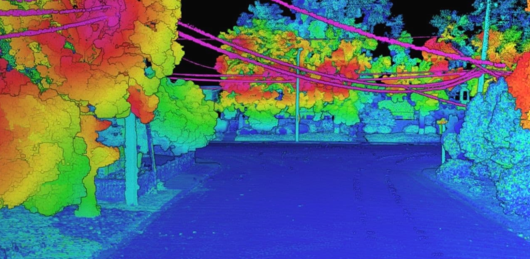
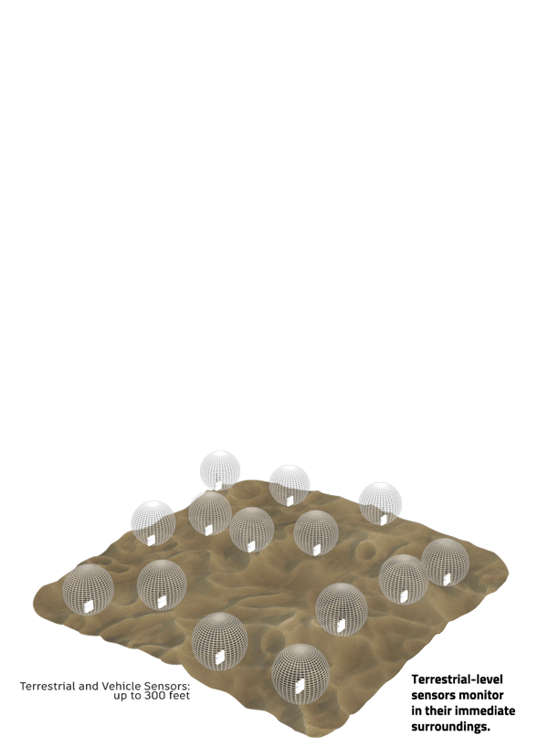
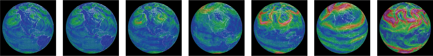
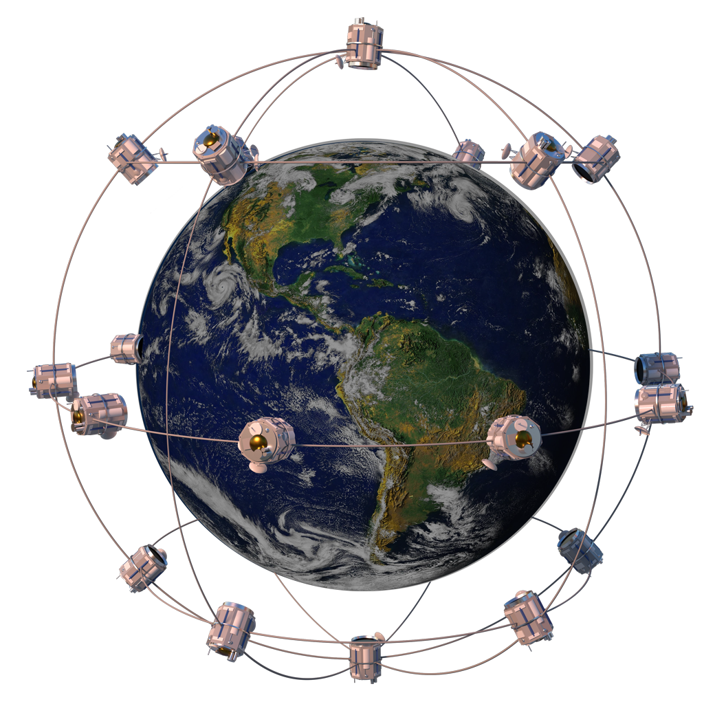
At the pinnacle of atmospheric monitoring capability, Scepter simultaneously collects atmospheric data from a global network of satellite-to-terrestrial-level atmospheric sensors across the entire, dynamic vertical air column. The network consists of space-based hyperspectral satellite sensors, aircraft, UAV, drone, and both fixed and mobile terrestrial sensors. Scepter’s Low Earth Orbit hyperspectral satellite sensors capture missing characteristics of elevation and chemical reactions and transport, monitoring real-world atmospheric conditions on a global, real-time basis. This global-to-local multi-sensor, multi-layer capture produces comprehensive data, with higher fidelity and greater precision than data captured from a single source or system.

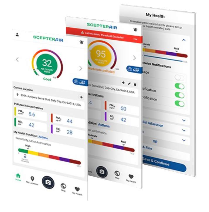
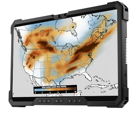
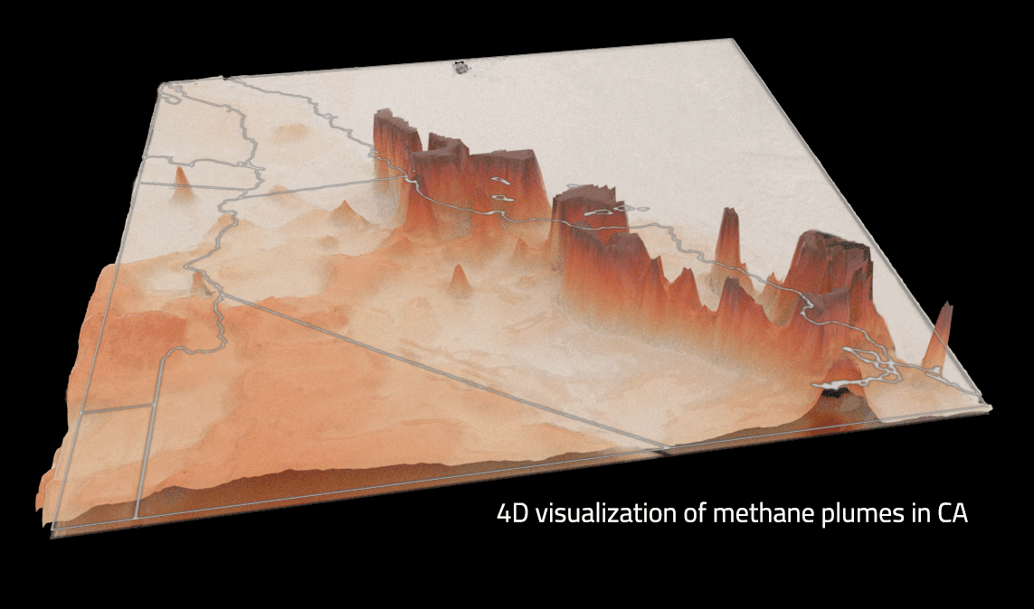
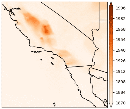
Monitoring is the first step of the ScepterAir technology platform that includes data aggregation, normalization, fusion, analytics, machine learning, and visualization. Multidimensional visualized presentation of atmospheric information provides comprehensive situational awareness. From monitoring to visualization, immutable data maintains full integrity as it evolves through the platform’s transformational pipeline. The real-time information produced provides actionable solutions: easy to understand, use, and employ for strategic decision-making purposes.

The ScepterAir data production pipeline can be utilized in part or in its entirety; one, some, or all of the pipeline steps may be engaged to meet environmental ESG reporting needs. Global-to-local, real-time atmospheric information can be customized to meet the specific objectives of technology service providers, organizations, government agencies, and NGOs.

Scepter is the premier provider of high-caliber, comprehensive atmospheric situational awareness. The patented ScepterAir technology platform enables the generation of entirely new, transformational, actionable information. Scepter is taking atmospheric monitoring to the next level, surpassing any other commercial offerings available today.

Advanced analytics powered by machine learning and artificial intelligence turns fused data into actionable information.

Information visualized in 2D, 3D, 4D, and XD add firepower to ESG reports and presentations.

Monitoring

Multi-sensor Monitoring within the Dynamic Vertical Air Column

Scepter monitors global atmospheric components and ingests data from a wide range of reliable, verifiable, independent and third-party atmospheric monitoring providers. The Scepter multi-sensor system captures data in the dynamic, multidimensional airspace. This is monitoring in motion; components in the atmosphere are constantly in flux, and many sensors are also in motion. Scepter simultaneously captures atmospheric data and climate variables throughout the entire vertical air column, from hyperspectral satellite sensors, aircraft, UAV, drone, and both fixed and mobile terrestrial sensors. Multi-sensor, multi-layer capture produces hard, real data, with higher fidelity and greater precision than data captured from a single source or system.

monitor & ingest

Criteria Air Pollutants: carbon monoxide, ground-level ozone, nitrogen dioxide, particulate matter (both 2.5 microns and 10 microns), and sulfur dioxide

Greenhouse Gases:  methane and carbon dioxide

Atmospheric Climate Variables: air temperature, precipitation, solar radiation, wind, water vapor, and cloud properties

Gain the value of vertical air column monitoring

Scepter monitors greenhouse gases, criteria air pollutants, and atmospheric climate variables.

Many isolated atmospheric sampling systems gather data. Each has its use, but they all have the same limitation—incomplete coverage. Ground sensors only sample in their immediate surroundings. Drones target specific patterns and are used for area-specific situational awareness. Aircraft-based sensors are great at upper elevations, but only travel limited transportation routes. UAVs and aerostats are newcomers that also only cover particular air spaces. Scepter’s global network of satellite-to-terrestrial-level atmospheric sensors monitor throughout the entire dynamic, vertical air column, comprehensively capturing characteristics of atmospheric composition, elevation, motion, atmospheric variables, and chemical reactions and transport.

Data
Aggregation

Process, Normalize, and Move Data into a Secure Location

Sensor-gathered data are moved into a central data repository where they’re then organized and normalized. With the large number of data formats monitored, normalization standardizes data in preparation for fusion.

process & normalize
DataFusion

Intelligent Combining of Multiple Aggregated Atmospheric Data Sets

Scepter’s patented data fusion process intelligently merges various datasets within the same model and context so they can be accessed, analyzed, and ultimately visualized. 

merge & structure

Scepter's Global Satellite Constellation

Scepter’s constellation of Low Earth Orbit satellites is in development, with optimized instruments to detect and measure methane, particulates, and other air pollution constituents.

Analytics &
Machine Learning

Applied Advanced Data Analytics Yield Actionable Results

Using machine learning, ScepterAir performs real-time, advanced cross-data-stream analytics applied to fused data making it more valuable—that is, actionable—for use.

what happened?
descriptive
analytics
why did it happen?
diagnostic
analytics
what's happening now?
realtime
analytics
when will it happen again?
predictive
analytics
how can we change the outcome?
prescriptive
analytics
quantify & predict
i
Visualization

Visualized Atmospheric Data and Information Delivered as Needed: 2D, 3D, 4D, and XD Presentation

Scepter provides dynamic real-time visualization of atmospheric information and data as it comes in, and, as it changes. Both data and information can be visualized at any step in the ScepterAir pipeline. Customized, visualized atmospheric data and information can be delivered as needed: 2D, 3D, 4D, and XD. Stereo capture enables visualization as a movie, not just a static image. With global, real-time capabilities, Scepter technology can determine pollutant point-of-origin and capture cross-boundary activity: necessary capabilities given the Paris Climate Accords. In visual terms, this holistic process produces a unique five-dimensional view of the atmosphere, such as a 3D matrix with both temporal and spectral dimensions. In addition to atmospheric components, atmospheric variables, like solar radiation, air temperature, and wind, can be included in computations and actionable visualizations.

Visual presentation of data and information provides comprehensive situational awareness. It’s easier and faster to understand than traditional forms like spreadsheets. Greater understanding enables the ability to take action. Scepter is the leading provider of commercially available global, real-time multidimensional rendering of the atmosphere’s dynamic composition.

2D visualization of methane plumes over CA

view & report

Scepter's Earth-observing Big Data Offering

Scepter produces high-integrity atmospheric information based on:

• Stereo data collection from space-based vantage points (Low Earth Orbit)

• Highly granular source data, including from multiple third-party sensor systems 

• Low-latency data: rapid delivery directly from source

• Immutable source data, verifiably unmodified, and stored

• Low-latency actionable information through a cascade of transformational steps

• Data integrity: accuracy and consistency of data is maintained over its lifecycle

• Data is blockchained after each transformational step, making it immutable and verifiable as stored

Contact us to learn more about our technology and services and discover how actionable atmospheric awareness will benefit your organization.